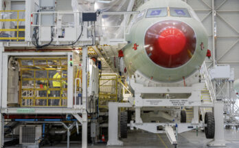
While the industry’s attention is often captivated by innovative designs, advanced propulsion technologies, and promised capabilities of eVTOLs, their safe and efficient integration into the National Airspace System (NAS) is equally critical to bringing them into service. The successful deployment of eVTOLs at scale will require a concerted effort to develop vertiport design and operational standards involving multiple stakeholders, including regulatory agencies like the FAA, city planners, private vertiport developers, utility providers, and eVTOL manufacturers. To support this integration, the FAA has begun developing comprehensive standards for the general layout, design, surface markings, and lighting of vertiports.
General Vertiport Design and Layout
While eVTOLs share some flight characteristics with rotorcraft, the existing helipad infrastructure is inadequate to accommodate them. This is due to the commercial and passenger-focused nature of eVTOL operations, which will lead to increased traffic levels, greater operational complexity, and the need for electric charging stations.
At a basic level, the layout of a vertiport will depend on its location and existing infrastructure. Ideal locations include heliports, general aviation airports, commercial airports, and even parking garages. Many decommissioned helipads that have been shut down due to inactivity also present valuable opportunities for conversion into vertiports. According to a study by the National Renewable Energy Laboratory, a standard vertiport design will require:
- A touchdown and lift-off area (TLOF)
- A taxiway
- Parked gate positions
- Passenger parking and terminals
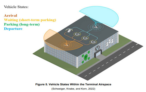
Vertiport Electrical Infrastructure Study. Image – NREL (https://www.nrel.gov/docs/fy24osti/86245.pdf)
FAA Standards for Vertiport Development
Vertiport Operations: Markings, Lighting, Procedures and Airspace
Although vertiport design and layout are relatively straightforward due to existing infrastructure that can support their development, integrating eVTOLs into the National Airspace System remains a significant challenge, as it requires entirely new operational frameworks. To address this, in December 2024 the FAA released an outline for the required design standards, markings, lighting, and airspace considerations for vertiports.
These required design standards developed by the FAA for vertiports are based on two key dimensions of eVTOLs, which are measured in feet:
- Rotor Diameter – The largest measurement from tip to tip of any rotor.
- Controlling Dimension – The diameter of the smallest circle that fully encloses the aircraft when viewed from above, including all possible rotor configurations.
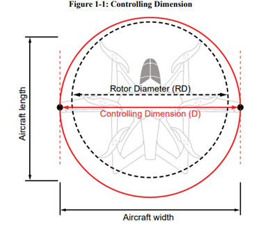
Using these dimensions, the FAA defines three required zones within vertiport takeoff and landing areas. The rotor diameter and controlling dimension are based on the largest eVTOL intended to operate at the vertiport, also known as the Design eVTOL aircraft:
Source: https://www.faa.gov/airports/engineering/engineering_briefs/eb_105a_vertiports
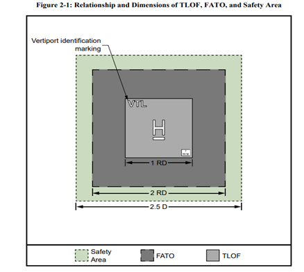
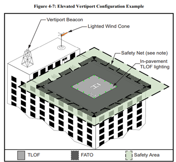
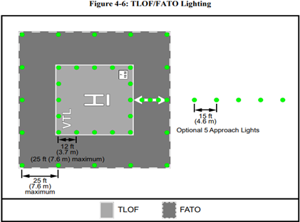
- Touchdown and Lift-Off Area (TLOF) – A load bearing, usually paved surface where eVTOLs land and take off. The FAA requires its dimensions to be at least one rotor diameter.
- Final Approach and Takeoff Area (FATO) – The area where eVTOLs complete their approach to hover or land and initiate takeoff. It is centered around the TLOF and must be at least twice the rotor diameter.
- Safety Area – A surrounding buffer zone intended to reduce the risk of damage in case of deviations from the FATO. The minimum required size is 2.5 times the controlling dimension.
Markings
To differentiate vertiports from traditional heliports and ensure safe maneuvering of eVTOL aircraft, the FAA requires distinct surface markings that include the following:
Identification Symbol: “VTL” and “H” markings in white letters in the TLOF, identifying the facility as a vertiport rather than a heliport.
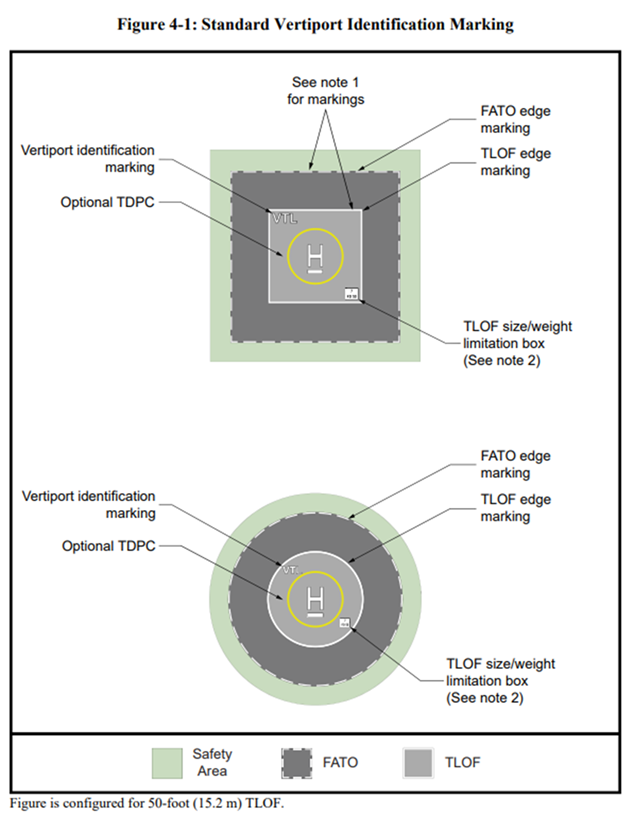
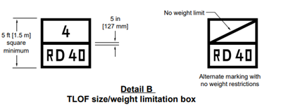
TLOF size/weight limitation: Box with black letters/numbers and a white background will be placed to denote the maximum takeoff weight and controlling dimension of an eVTOL that can be operated at the vertiport. The top number is the maximum takeoff weight in thousands of pounds of an eVTOL the TLOF can accommodate and the bottom number is the controlling dimension of the largest eVTOL aircraft the field can accommodate in feet, and is preceded by the letters “RD.” TLOF without a weight limit is marked with a diagonal line extending from the lower left-hand corner to the upper right-hand corner in the upper section of the TLOF size/weight limitation box.
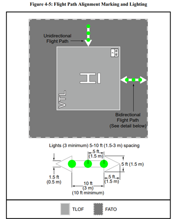
FATO Markings: White dashed lines outlining the Final Approach and Takeoff area. The FAA has also made the flight path alignment marking within the FATO optional, as seen in Figure 4-5. For a vertiport with a flight path limited to a single approach direction or a single departure path, the arrow marking is unidirectional.
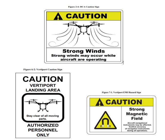
Other markings and signs will be required at vertiports due to the unique nature of eVTOL operations. For example, eVTOLs in flight create significant downwash or outwash airflow that can be hazardous to persons, equipment and other aircraft. The FAA has created a Downwash Caution Area sign that can be used in downwash/outwash caution areas to alert persons or vehicles within the vicinity. It is important to note that the Downwash Caution Areas will extend beyond the safety area, and their dimensions will depend primarily on the design and layout of each vertiport. Additionally, the FAA has yet to give guidance on eVTOL taxi-way markings or operations but said it will do so in its next engineering brief, though it is unknown when this will be released.
Lighting
Like civil aircraft operations, the FAA has chosen to require lighting systems for vertiports that support night operations for pilots to establish the location of the vertiport in addition to the operational perimeter of the field. The FAA has established the following guidelines for vertiport lighting:
Airport Beacon/Wind Cone: Like heliports, the FAA requires a flashing white/yellow/green beacon to be installed at vertiports supporting night operations. However, on-airport vertiports are not required to have a vertiport identification beacon and will be identified by the alternating white and green airport beacon. At least one orange wind cone that is visible to pilots at least 500 feet from the TLOF is also required.
TLOF and FATO Lighting: Green lights placed at 5- to 7.5-foot intervals around the edge of the TLOF. FATO perimeter lights are optional but must green lights outlining the FATO, with a spacing of at least 10 feet apart to define approach and departure paths.
Approach Lighting Systems (ALS) and Flight Path Alignment Lighting (Optional): Approach lights and flight path alignment lights are optional.
As the race to develop and produce eVTOLs accelerates, it becomes increasingly clear that success hinges on far more than just the development of these vehicles themselves. Without the proper infrastructure, the widespread adoption of eVTOLs will remain an unrealized potential rather than a tangible reality. The creation of robust, scalable vertiport networks and the development of operational standards will be key in ensuring eVTOLs can be integrated safely into the NAS.

With diverse experience in the commercial aviation industry, Grant joins Forecast International as the Lead Analyst for Commercial Aerospace. He began his career at the Boeing Company, where he worked as a geospatial analyst, designing and building aeronautical navigation charts for Department of Defense flight operations.
Grant then joined a boutique global aviation consulting firm that focused on the aviation finance and leasing industry. In this role he conducted valuations and market analysis of commercial aircraft and engines for banks, private equity firms, lessors and airlines for the purposes of trading, collateralizing and securitizing commercial aviation assets.
Grant has a deep passion for the aviation industry and is also a pilot. He holds his Commercial Pilots License and Instrument Rating in addition to being a FAA Certified Flight Instructor.